
Day 1
I took half day off and hoping we can get to the Arches National Park Visit Center before it closed to reserve the guided tour hike of the Fiery Furnace. I think, it's only 4 to 5 hours drive, OK let's do it. Yes, we made it and it comes with a speeding ticket... Yea, my very first speeding ticket. Believe it or not, I didn't speed on the highway, just didn't slow down enough when passing a small town called Price. Like the name of the town, the ticket is pricy and $90 is gone! We arrived around 25 minutes before the visitor center closed. Bad thing is that the guided Fiery Furnace hike tickets are sold out for the next 3 days. There still non-guided tickets left but the ranger did not recommend as people can easily get loss inside. I guess, I will save it for next time.
Since we arrived earlier than we expected and the sun now won't set until 8 or later, we decided to visit the Dead Horse Point State Park. I wasn't so interest in this park before the trip but my co-work highly recommended. According to my co-worker, it is a wide open space with cliff on all side except a think neck connected to the land which allow the Indians kept their horses in the old time. We saw the sign on the way to Arches and it's only a 45 minutes detour. I gotta tell you, it totally worth it. There are just view points without any intensive hike. Good "warm up" for our trip. We enjoyed the beautiful views and the sunset there. Well, maybe "half sunset", the sun was totally blocked by a big cloud! After that we had dinner at my favorite diner in Moab, the Moab Diner. If you ever got a chance to go there, make sure to order the green chilli and ice cream, they are very good! At that happy moment, we didn't know the crazy thing we did the next day!!


Day 2
Next day, we spent the entire day at Arches. Third time for me at Arches but still so much to discover. We started at the Devils Garden at the end of the park. Enjoying the extraordinary landscape views during the drive and stopped by for pictures. At Devils Garden, we saw Tunnel, Pine Tree, Landscape and some other small arches just like other common tourists did. My last visit with my parents, I stopped at the area next to the broken Wall Arch. The deep cliff next to the trail is very scary but the Double O Arch located further down that trail is quite tempting for me this time. So, I decided I won't stope. We successfully passed the scary part. We got so excited that we missed the Double O Arch Trail Head sign. After almost 2 hours, we started getting worried but didn't want to turn back, as we made it this far. At the moment we wanted to give up, we found the right path and saw people coming.
We immediately asked, "Is there the direction to the Double O Arch?".
The tourist answered, "No, this is the trail head."
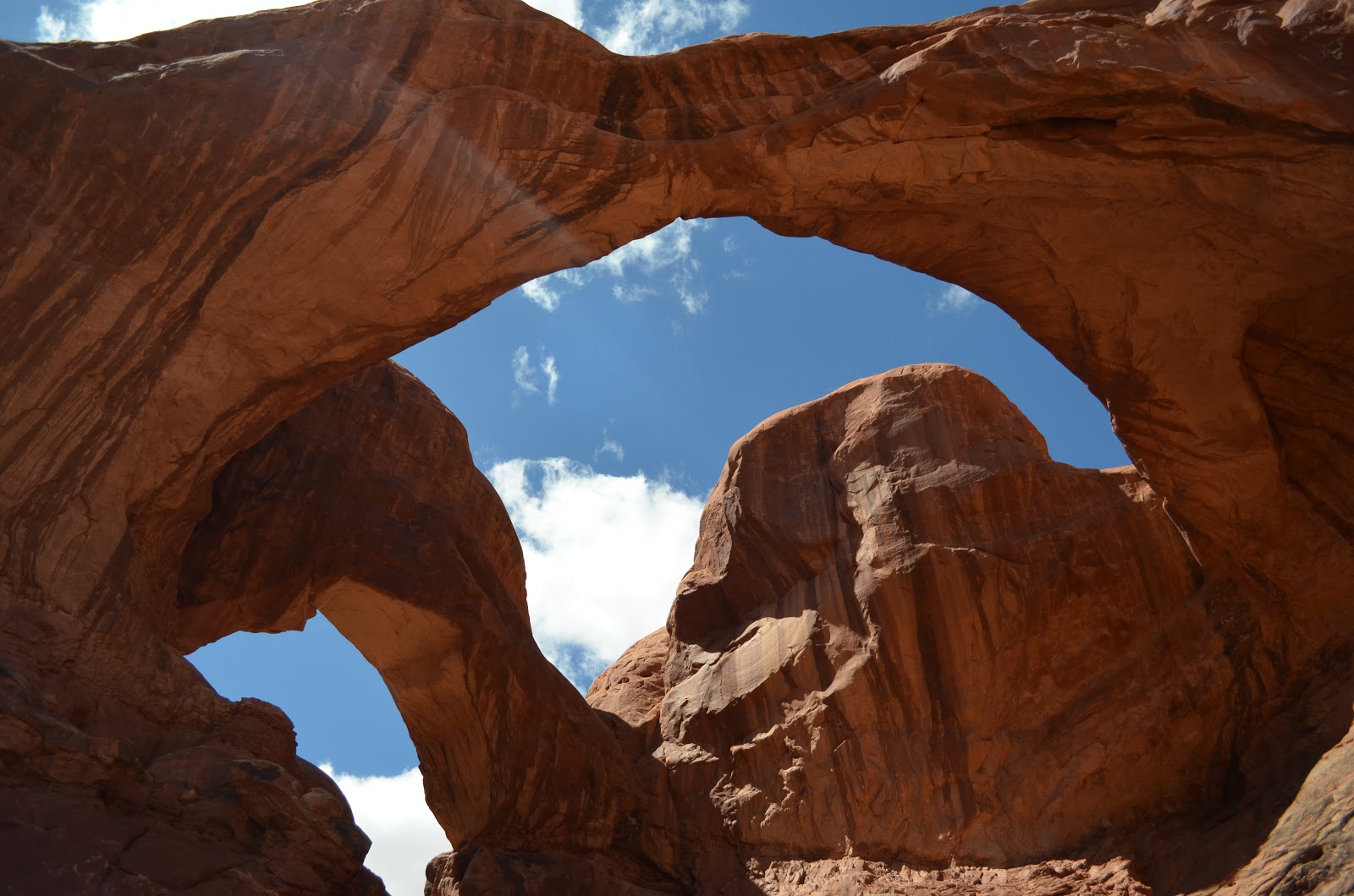
Yea, we stuck in the beginning of the trail for almost 2 hours!!! We all laugh out loud. So, we kept hiking. The brochure did not lie. It is a strenuous trail. Sorry, didn't have much pictures on the trial. I was so scare, deep cliff next to trail everywhere. My friend's face was totally pale! The Double O Arch is huge. We climbed through the lower small "O" to get a better view behind the arch. There, you can also see the Dark Angel. A crazy hiker even climbed up the top of the arch.


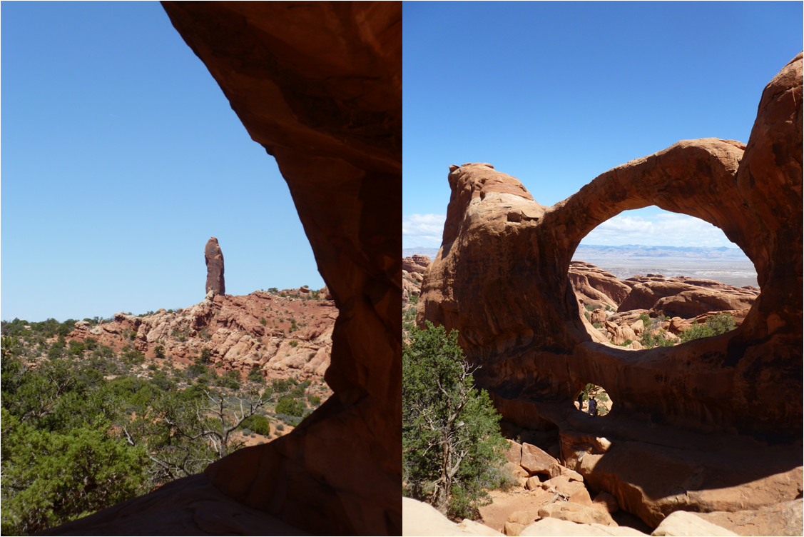
After the Double O Arch, we decided not to hike to the Dark Angel. Instead we head to the Window Section. The Window Section is relative easy part inside the park. I wouldn't consider them as hiking trail but view points. There, we visited the North & South Windows, the Turret Arch and the beautiful Double Arches. After that, we head back to the hotel to take a quick late lunch break before heading to our major attraction of the park.


We started hiking to the Delicate Arch about 3 hours before sunset. The hike was so much easier than I remembered. I don't know if it is because I hiked there almost 8 or 9 years ago and losing my memory or the difficult Double O Arch hike during the morning make this hike relatively easy. My sister told me they did make a better path for the hike on 2004, maybe it is easier than the hike I did before. The most difficult and scary part is at the end hiking to the bottom of the arch, which is optional. You are already very close to the Arch even without this last I felt like I would slip and fall. I still can't believe I actually touched the arch! Since it was close to sunset, there were a lot of photographers waiting for the arch turns red during sunset. We did not stay until the sun totally set. We are not professional hikers and all we had are small torch lights. We were worried that we will get loss. The most amazing thing I saw there is actually a guy, who weigh more than 400 pounds, he made it all the way to the top!!!


Day 3
Originally, we think this day would be less intense but it ended up the hike is longer than we though. First stop, we went to the Goblin Valley State Park. I want to go there since the first time I hear about the name "Goblin" but people keep telling me it is for kid and it is true. It is a cool place with lots of goblins but that is pretty much. However, if you have kid, this is the perfect place. We saw kids having so much fun playing hide & seek between the goblins. We took some pictures and had a picnic there. We even had the macaroons I made for dessert!

Next, we head to the Lower Calf Creek Falls through the famous Highway 12 Scenic Byway. It's another 3 hours drive but totally worth it. The highway passes through (in the order how we passed through) Capitol Reef National Park, Dixie National Forest, Boudler Mountain, Grand Staircase-Escalante National Monument, Bryce Canyon National Park (our last destination) and Red Canyon. You will never get bored on this drive. The landscape dramatically changes on the highway. A moment you are at the dessert near the Capital Reef area, the next moment you are in the high altitude Dixie National Forest with snow all covered. Even this is my second time, I still amazed by the views.


We arrived at the Lower Calf Creek Fall around 3 p.m. and thought it is a maximum 3 hours hike. We were wrong! It is a minimum 3 hours hike. The trail head is located on the Hell's Backbone Road between Boulder and Escalante. Our original plan was hike and then drive back to a restaurant located near Boulder called, Hell's Backbone Grill, to have dinner. However, due to our under estimation, we didn't finish the hike until 7:30 p.m. Without the bright sun light, I was a bit shaky driving back on the Hell's Backbone Road. As you can tell from the name, it is quite dangerous drive. Part of the road have calf on both side!!!
The hike was OK. Not much to see on the way but it was 90% cover in shade. You can just follow the sound of the running water from the creek. Just like the day before, we got loss in the beginning of the trail. We realized we were loss when we couldn't hear the running water. We easily found our way back on the trail. You cannot see anything until you make a turn at the end and the beautiful waterfall is right there. It is a colorful 126-feet drop waterfall. The red sandstone gives a great contrast on the water and the algae growing on the sandstone gives additional yellow and green color on the falls. It is gorgeous!!!


After the hike, I brought my sister and her friend to a cool place at Escalante called, Escalante Outfitters, to re-charge. My friend brought me there last time I was there. This is the only place in Escalante that serve beer. I was the driver, so, I didn't drink. We had pizza and cool ice tea for dinner and back on the road to our other destination, Bryce Canyon.

Day 4
We had a good night sleep at the Ruby Inn located right at the entrance of the Bryce Canyon National Park. We had a room at the Lake View Lodge building and it really does have a lake view! This is my third times to the park but the first time I actually see the park. The last two times I was there, I just passed by and only took a picture at the Sunset Point. I was so excited to actually see the park.

Thunder storm is quite common at the Bryce Canyon National Park. We were lucky it was a sunny day but weather forecast said it will rain in the afternoon. So, we decided to do the hiking in the morning. Looking down at the Bryce Canyon from the top is already extraordinary but it can't compare to hiking d.own at the canyon.

We started at the Sunset Point and walked part of the Rim Trail to the Sunrise Point. Of course, we enjoyed the overlook of the entire canyon during the hike. From the Sunset Point we started walking down to the canyon and head to the Queen Garden Trail. The hike is only moderate level. Bryce Canyon is quite distinct from other parks we visited in the first couples day of our trip. We enjoyed very much of this easy hike. At the Queen Garden trail head we saw the "Queen Victoria". After that, we hesitated for a moment because suddenly everyone is gone! From the visit center, we learn that there are cougars in the canyon and we were afraid we will be alone and see some cougars on the trail. However, we decided to keep going. Within 2 minutes, we saw people coming at the opposite direction. We laugh out loud again because we were so silly and chicken!!! We hiked between the trees and finally arrive the Navajo Loop. The last part of our hike is called, Wall Street. It is a "Z" shape trail go back up to the Sunset Point. It was quite a hike but it was amazing!!!! The hike is almost vertical in a very narrow canyon. It was so much fun! Just one imperfect is that the other side of the Navajo Loop was closed due to the rain the night before and we couldn't see the Thor's Hammer there.


After the hike, it's start raining. We drove back to a little town called, Tropic, and have lunch at a place called, Clarke's Restaurant. Food was just OK there. I don't know why we drove all the way there to eat. We headed back to the park and drove to the view points. We saw the Farview Point, Natural Bridge, Agua Canyon, Ponderosa Point and Rainbow Point, etc. I gotta say nothing really impressive of the view point, but the Rainbow Point actually has an elevation of 9115!!! I felt pressure on my heart and hard to breath. So, I asked my sister to drive us down. We spent the remaining afternoon wondering around the old town across the Ruby Inn. After a short rest, we attended the free night program at the park. There were a lot of people waiting for the night section when we arrived. We learn a lot about stars at the section. But because of the heavy clouds, the ranger didn't bring out the telescope to show us the stars.


Day 5
We slept as much as we could before waking up and driving back home. We stopped by the diner of the Bryce Canyon Resort to have breakfast before heading to the freeway. The place served typical American food and it was good. There is a set of comedian books on the table to entertain you while waiting for your food. But just to let you know ahead, those books weren't written by the owner (I asked already :P).

It was such a good trip (except the speeding ticket). I felt I did and see so much. Can't wait to explore some other part of Utah in the future!!!
Happy Blogging - Vee
No comments:
Post a Comment